|
by Neil Tandon for the Roosevelt Island Historical Society©
ROOSEVELT ISLAND PUBLIC SCHOOL &
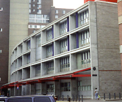
The K-8 ROOSEVELT ISLAND PUBLIC SCHOOL (P.S./I.S. 217M), designed by acclaimed architect Michael Fieldman and Partners, opened in 1992. Before 1992 students were split into five mini-schools:
Main Street was the students' hallway, and Sportspark (south of the Tram) was their gym.
This $28 million, 93,000 square-foot structure has its own two-story gymnasium, an auditorium, modular classrooms, a waterfront cafeteria, a library, a fine arts wing, and generous playground space. The school's 570 students speak some 14 languages and represent 36 nationalities, many of them children of United Nations staff and diplomats. P.S./I.S. 217 has rated as one of Manhattan's best public elementary schools, with consistently excellent reading scores and high acceptance to the city's specialized secondary schools. Looking up to your right, you see one of the two red towers of the ROOSEVELT ISLAND BRIDGE. This 418-foot long vertical lift draw bridge (operated by the New York City Department of Transportation) opened on May 18, 1955, as the Welfare Island Bridge. It replaced the Queensboro Bridge's Elevator Storehouse as the island's only vehicular connection. (The elevator closed in 1955 and was demolished in 1970.) Rising 40 feet above the East River's East Channel, the bridge can draw to a height of 103 feet, though, save for testing, it is seldom done. (Most tall boats simply take the East River's West Channel.) The bridge has had three different paint coats: blue, gray, and its present red. Originally, this bridge exited onto what is now the Manhattan-facing seawall until its spiral ramp, exiting onto Main Street, was built in 1974. Each building is a variation on a U-shaped plan, with the open portion containing a river-facing courtyard. In addition, each complex was designed to "step down" to the river, taking advantage of river views and preserving the open-aired feeling of the river promenades.
The artery through all these buildings is appropriately named Main Street. Architects Philip Johnson and John Burgee designed the street with a gently zig-zagged route, both to lend curiosity to the path and to make it seem shorter than it already is. Each building has its own array of storefronts, giving Roosevelt Island "one of everything." Here's just a partial list of the island's many commercial establishments: deli, stationery store, library, bank, diner, laundromat, pizzeria, Chinese restaurant, flower shop, thrift store, fish store, credit union, liquor store, and bakery. |
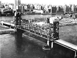
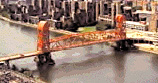 Above: Welfare Island Bridge, ca. 1969.
Right: Roosevelt Island Bridge, 1999.
Above: Welfare Island Bridge, ca. 1969.
Right: Roosevelt Island Bridge, 1999.