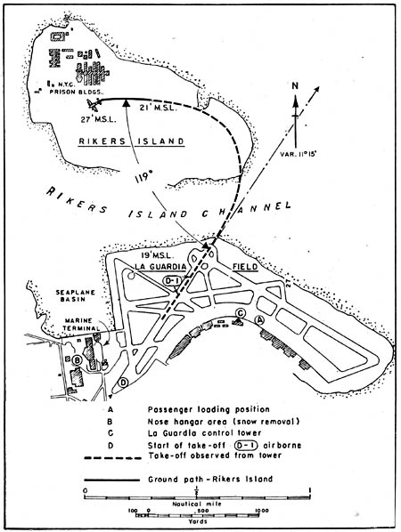
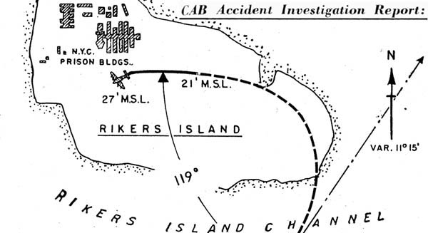
 Above: Detail from map in CAB report on crash of Flight 823 on Rikers Island Feb. 1, 1957. |
There were 101 persons aboard the aircraft -- 95 passengers (which included 11 children) and six crew members. Of these 20 passengers received fatal injury, 25 passengers and three stewardesses serious injury, and 50 passengers minor injury. The pilot, copilot, and flight engineer were uninjured. The aircraft received major damage from ground impact and was destroyed by subsequent ground fire. Northeast Airlines Flight 823, a DC-6A, N 34954, was scheduled to originate at La Guardia Field, a nonstop to Miami, Florida, with a departure time of 1445. This aircraft and the same crew, operating as Flight 822, had arrived at La Guardia from Miami at 1250. . . . Snow, which had started at La Guardia at 1202, began to accumulate on the aircrafts horizontal surfaces after its arrival at the La Guardia ramp position. Snow removal by ground personnel, during pre-flighting, was ineffective because of the continuing snowfall.
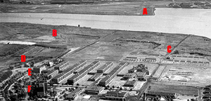
This was accomplished and at 1745 the crew advised La Guardia ground control that they were ready to taxi from the nose hangar for the IFR departure to Miami. Flight 823 was then cleared to runway 4 and was advised that the wind was north- east 10, altimeter setting 30.12, and a time cheek of 17471. Air Route Traffic Control cleared the flight as follows: Cleared to Bellemead, maintain 7,000 ft. A supplementary climb-out clearance was then given: After takeoff, a left turn direct Paterson, direct Chatham, cross 081- deg. radial of Caldwell 4,000 ft. or above, cross Paterson between 5,000 and 6,000 ft. and cross the northwest course of Idlewild, not above 6,000 ft." Both clearances were repeated and acknowledged . . . . Fire equipment and assistance were supplied promptly by personnel from the nearby city penal institution on Rikers Island. Those who had been able to leave the aircraft were conducted to shelter and given medical aid.
Flight 823 first struck small trees while on a heading of 285 deg. magnetic. The left wing tip struck the ground first; the right wing tip struck 150 ft. beyond. The aircraft, after striking the ground nearly level longitudinally, skidded approximately 1,500 ft. and came to a stop on a heading of 241 deg. The ground elevation differential between the initial impact point and the stopping place is less than 10 ft. It was determined that the angle of descent at impact was seven degrees. Groundspeed at impact, computed from propeller slash marks and engine rpm., was approximately 138 kt.
The airplane struck the ground while descending in a slightly left wing low attitude. Numbers 1 and 2 engines separated from their nacelles and subsequently the entire left wing and outer right wing parted from the airplane as it skidded along the ground.
Those near the point of initial impact showed no signs of fire damage. No pieces of the airplane were found back along the flight path beyond the point of initial impact of the airplane with the ground. The main wreckage consisted of the fuselage, the right inboard wing, and the empennage. The fuselage belly had been flattened and torn away during the ground slide . . . |
 |  |
To List of DOC staffers honored for air crash response.
To: List of names of those aboard Northeast Airlines DC-6A Feb. 1, 1957
To The Andersons of Canada remember.
To Remembering Mario DeRosa.
To Remembering Esther Chopelas.
To: Other views, other voices: Rikers air crash
To: 1989 airplane crash into Rikers Island channel waters
To: NYCHS home page.
To
NYC DOC history menu page.