|
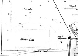
Correction Facilities -- map showing Clinton CF in relation to other NYS correctional facilities and showing its catchment area. Major Cities -- map showing location of Dannemora and Plattsburgh in relation to other NY cities. Regional -- map showing Dannemora and Plattsburgh in relation to other major locations in its region of NYS. Topographic map #1 -- detail from topographical map showing Clinton State prison and State Hospital. Topographic map #2 -- diagram depicting the rising elevations of the prison grounds. The Yard & the Courts -- map showing inmate recreation yard patio courts in relation to other features in the prison. Webmaster Note: Because reducing some 8.5x11 inch maps to fit a web page screen renders most of their words too small to be read, only the most relevant sections of those maps are presented. In Topography Map #2, words from the larger version of the map image -- originally spread out over two pages -- were pasted over their corresponding unreable words on the reduced-to-fit version of the map image.
|