cate the bottom dropping off to a trench along -the westerly edge of the original island rising to a broad shoal area and then going down into a 61 foot deep hole toward North Brother Island (the north tip of the present island).
|
As did the text on the printed Page 140, the text on this web page begins with the continuation of a sentence begun on Page 136. Likewise the text on this web page ends in mid-sentence as did the text on the printed Page 140.
 Left is an image of the entire Page 140 from which the article text on this web page was taken.
Click on the image left to access an Adobe Acrobat (PDF) downloadable and printable scanned copy (526 Kb) of the original Page 140.
Use your browser's "back" button to return to this page in order to navigate through the rest of this presentation.
|
|
Immediately on top of this rock was a layer of silt. When the fill was placed over the silt, the area over the rock slope experienced lateral movement as the silt slipped down the slope due to the weight of the fill.
The movement of the piles caused cracking of grade beams, cracking of brickwork, cracking of concrete spandrel beams, settlement and distortion of floors in adjacent buildings.
The information gathered from investigations and reports on the above failures was applied to the design of subsequent projects (figure 4). [Webmaster Note: "Figure 4" actually became Figures 4A, 4B & 4C on pages 137 and 138.]
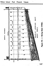
Figure 4A -- Boring Data (1946).
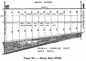
Above is a reduced image, turned horizontal, of Figure 4a on Page 137 in the 1972 third quarterly Municipal Engineers Journal issue.
Figures 4B & 4C - Boring Data (1946).
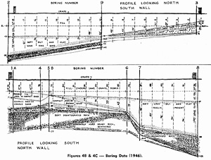
Above is a reduced image, turned horizontal, of Figures 4B & 4C on Page 138 in the 1972 third quarterly Municipal Engineers Journal issue.
Click either above image to access a larger version but still horizontal.
 Left is a reduced image, rasterized from an Adobe Acrobat (PDF) file of Page 137 featuring Figure 4A in its original vertical orientation, Left is a reduced image, rasterized from an Adobe Acrobat (PDF) file of Page 137 featuring Figure 4A in its original vertical orientation,
To access an downloadable and printable scanned PDF copy (306K) of the original Page 137, click on its image left.
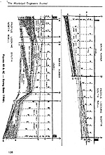 Left is a reduced image, rasterized from an Adobe Acrobat (PDF) file of Page 138 featuring Figures 4B & 4C in their original vertical orientation, Left is a reduced image, rasterized from an Adobe Acrobat (PDF) file of Page 138 featuring Figures 4B & 4C in their original vertical orientation,
To access an downloadable and printable scanned PDF copy (341K) of the original Page 138, click on its image left.
You can use Acrobat's Rotate View feature to make the PDF image horizontal.
If you access the PDF version, use your browser's "back" button to return here in order to navigate through the rest of this presentation.
|
|
A current review of the island reveals a constant upgrading of facilities in a never ending attempt to conform with current penal philosophy, both in new construction and in the rehabilitation of existing buildings.
Several studies have been made in the past in an attempt to channel this philosophy into a logical growth plan. Times change and so does thinking.
The successful master plan allows for such fluctuations. The most current plan by John J. Kassner & Ca., Inc., carries the island's development from 1964 to 1974.
The island is made up of -a series of complexes, each one taking care of a need that is best done in isolation from the rest of the island's inhabitants (i.e. the new Adolescent Remand Shelter that will completely separate the youthful offender from the older one). The present Adolescent Division physically abuts the Adult Division.
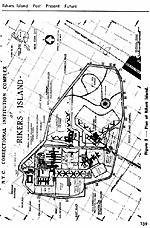
In order to give you a grasp of the magnitude of construction that the island has experienced since 1960, causing it to assume the configuration indicated on this overall plan (figure 5) I shall attempt to give you a brief summary of each of the projects involved along with each of their salient features.
Capital Project C-71 penitentiary phase consisted of the construction of an additional facility onto the existing penitentiary, to house both sentenced and remanded inmates. This phase consisted of two X-shaped buildings containing individual living quarters for 480 inmates, Administrative, Gymnasium and kitchen facilities.
Figure 5 - Plan of Rikers Island.
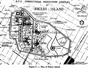
Above is a reduced image, turned horizontal, of Figure 5 occupying Page 139 in the 1972 third quarterly Municipal Engineers Journal issue.
Click the above image to access a larger version of the image but still horizontal).
 Left is a reduced image, rasterized from an Adobe Acrobat (PDF) file of Page 139 featuring Figure 5 in its original vertical orientation, Left is a reduced image, rasterized from an Adobe Acrobat (PDF) file of Page 139 featuring Figure 5 in its original vertical orientation,
To access an downloadable and printable scanned PDF copy (302) of the original Page 139, click on its image left.
You can use Acrobat's Rotate View Clockwise feature to make the PDF image horizontal.
If you access the PDF version, use your browser's "back" button to return here in order to navigate through the rest of this presentation.
|
|
A connecting corridor goes through the middle of the X splitting it into two (2) chevrons (V) thus enabling one guard position to control two (2) housing wings during periods when the inmates are secured in their cells. This plan broke down the inmates surroundings to a more human scale.
The original penitentiary consisted of seven cell blocks and separate buildings devoted to administration, receiving, detention, bath house, mess halls, kitchen, chapel and library, each of which is attached at right angles, to the main connecting corridor. This architectural design is similar to the prison erected in Fresnes, France in
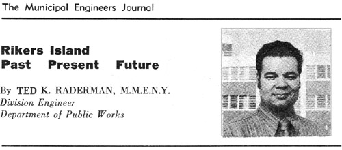
 Rikers Island: Past, Present, Future by then Public Works Department Division Engineer Ted K. Raderman in The Municipal Engineers Journal third quarterly issue, 1972, Vol. 58, pages 132 through 153. All copyrights remain reserved and retained.