of the new Correctional Institution for Women. The history of this mini-city is traced back to the Riker family, the original owners who used it for farming.
|
As did the text on the printed Page 136, the text on this web page begins with the continuation of a sentence begun on Page 132. Likewise the text on this web page ends in mid-sentence as did the text on the printed Page 136.
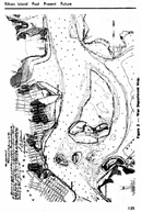
 Left is an image of the entire Page 136 from which the article text on this web page was taken. Left is an image of the entire Page 136 from which the article text on this web page was taken.
Click on the image left to access an Adobe Acrobat (PDF) downloadable and printable scanned copy (788 Kb) of the original Page 136.
Use your browser's "back" button to return to this page in order to navigate through the rest of this presentation.
|
|
They subsequently sold the island to the City in 1885 and it then became known as the "Municipal Farms" with its fields being tendered by inmates transported there daily from the penal institutions on Blackwell's Island (Welfare Island), located about 1.5 miles away in the East River.
Around 1930 the City was faced with the problem of replacing its
existing outdated facilities on Welfare Island. This continual problem
of , replacing outmoded facilities with modern ones while still staying
operational determined the selection of Rikers Island as a new penal
center, since it already was under the jurisdiction of the Department
of Correction.
From 1935 to 1954 the island housed a penitentiary for men including supporting utility service and access facilities such as the ferry slip, visitor's building and warehouses (figure 2).
Figure 2 -- View of Old Ferry Slip.
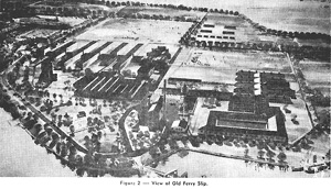
Above is a reduced image, turned horizontal, of Figure 2 occupying Page 134 in the 1972 third quarterly Municipal Engineers Journal issue.
Click the above image to access a larger version of the image but still horizontal).
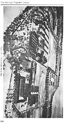 Left is a reduced image, rasterized from an Adobe Acrobat (PDF) file of Page 134 featuring Figure 2 in its original vertical orientation, Left is a reduced image, rasterized from an Adobe Acrobat (PDF) file of Page 134 featuring Figure 2 in its original vertical orientation,
To access an downloadable and printable scanned PDF copy (1,059 Kb) of the original Page 134, click on its image left.
You can use Acrobat's Rotate View Counterclockwise feature to make the PDF image horizontal.
If you access the PDF version, use your browser's "back" button to return here in order to navigate through the rest of this presentation.
|
|
The island's future potential was realized in 1954 and a major expansion of its correctional facilities was initiated and is still underway.
The original island covered an area of less than 90 acres. A War Department map (figure 3) dated January 24, 1893, shows the boundaries of the island at that time.
It contained little or no organic silt while bedrock was found to be approximately 25 feet down from existing grade.
The island's topsoil is a 6 inch layer of fibrous organic matter which has evolved from sporadic growth and deterioration of vegetation over the years. It is highly permeable and only after proper compaction to increase its water holding abilities will it support the growth of grass.
Its permeability on the other hand makes it immune to frost action. Huge boulders presumably left there during the ice age have been encountered in the northern part of the island during pile driving operations.
Figure 3 -- War Department Map.
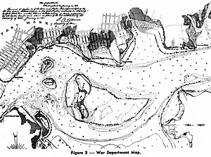
Above is a reduced image, turned horizontal, of Figure 3 occupying Page 135 in the 1972 third quarterly Municipal Engineers Journal issue.
Click the above image to access a larger version of the image but still horizontal).
 Left is a reduced image, rasterized from an Adobe Acrobat (PDF) file of Page 135 featuring Figure 3 in its original vertical orientation, Left is a reduced image, rasterized from an Adobe Acrobat (PDF) file of Page 135 featuring Figure 3 in its original vertical orientation,
To access an downloadable and printable scanned PDF copy (557 Kb) of the original Page 135, click on its image left.
You can use Acrobat's Rotate View Clockwise feature to make the PDF image horizontal.
If you access the PDF version, use your browser's "back" button to return here in order to navigate through the rest of this presentation.
|
|
Organic silt formed the bed of the East River that surrounds the island and subsequent filling operations either displaced or entrapped and consolidated it, creating unstable subsoil conditions.
The filling operations helped Rikers Island grow to 400 acres in total land area. Part of this fill during the 1920's and 30's was in the form of garbage dumping. A trestle constructed from Astoria (North Beach) was used to transport the garbage to the island.
The recent completion of the Women's Correctional Institution and the currently under construction Adolescent Remand Shelter were preceded by an enormous filling operation that raised the grade in the central portion of the island approximately 12 feet over an 120 acre area.
This fill and earlier fill caused much havoc with the composite piles supporting the earlier buildings, because these piles were not firmly set on rock. Early War Department soundings indi.
 Rikers Island: Past, Present, Future by then Public Works Department Division Engineer Ted K. Raderman in The Municipal Engineers Journal third quarterly issue, 1972, Vol. 58, pages 132 through 153. All copyrights remain reserved and retained.